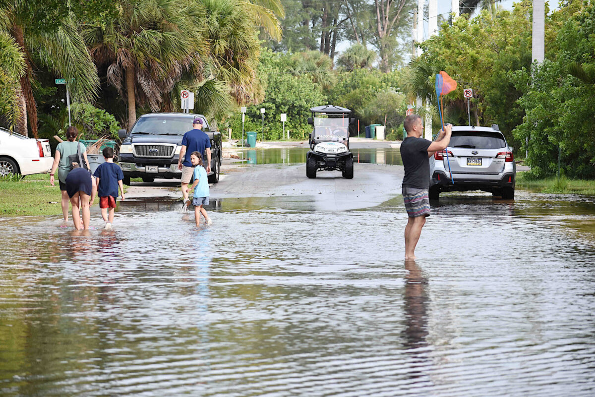
Elsa’s rains flooded North Bay Boulevard, near the Bean Point beach access in Anna Maria.
Photo: Joe Hendricks
ANNA MARIA ISLAND – An early Wednesday morning tour of Anna Maria Island revealed Hurricane Elsa’s impact was minimal in the three Island cities.
The storm that passed through Anna Maria Island Tuesday afternoon and evening and into Wednesday morning produced localized flooding but no reports of significant property damage, one reported fallen tree and no reported downed power lines or power outages on the Island.
According to Wunderground.com – an affiliate of The Weather Channel – the highest wind gust recorded at the Sarasota-Bradenton International Airport weather station during Elsa was 54 mph at 10:53 p.m. Tuesday evening.
Wednesday morning, Anna Maria resident Doug Copeland said he and his wife’s rain gauge indicated 2.8 inches of rain fell during Elsa at their home near the Rod & Reel Pier.
Bradenton Beach
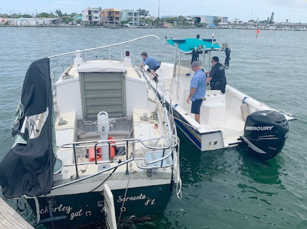
According to Bradenton Beach Public Works Director Tom Woodard and Lt. John Cosby from the Bradenton Beach Police Department, at approximately 11 a.m. Tuesday morning an unoccupied sailboat on the Cortez side of the Intracoastal Waterway (ICW) broke free of its mooring and began drifting toward the Bridge Street Pier in Bradenton Beach.
Officer Eric Hill and members of the Bradenton Beach Public Works Department secured this sailboat that broke loose on the Cortez side of the ICW.
Photo: Bradenton Beach Police Department | Submitted
“We were able to go out and get it and get it tied up and secured. They got it under control and out of the way before it caused any problems,” Cosby said, noting that Officer Eric Hill piloted the police boat stationed on the police boat lift adjacent to the pier.
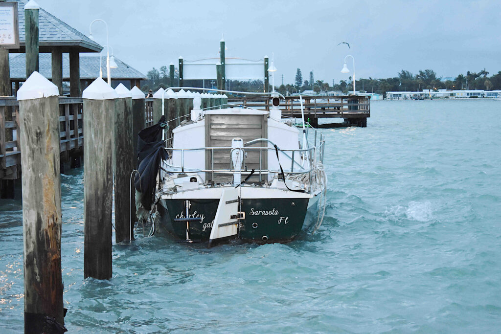
Cosby and Woodard said the pier and the floating dock sustained no damage during the storm. Cosby said it may take a few days to have the sailboat removed.
The sailboat that broke loose Tuesday morning remained tied to the Bridge Street Pier Wednesday morning. Photo: Joe Hendricks
A 7 a.m. visit to the pier Wednesday morning revealed the sailboat was still secured to the dolphin pilings at east end of the floating day dock and none of the 15 or so liveaboard vessels anchored south of the pier had broken free or sunk during the storm. The one sunken vessel currently in the area sank long before Tuesday’s storm.
“Everybody did what they needed to do,” Cosby said of those liveaboard boaters.
According to Cosby, Officer Hill contacted many of them via cell phone on Monday and reminded them to secure their vessels with double anchors before the storm arrived.
“It appears everybody did it, because I don’t see any issues,” Cosby said.
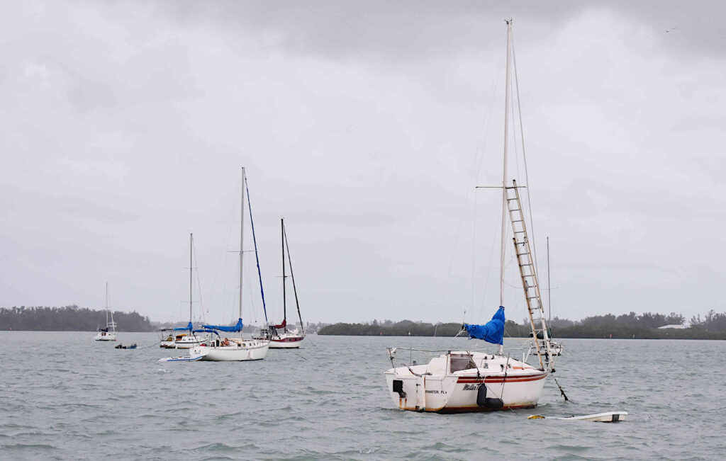
The liveaboard boaters south of the Bridge Street Pier weathered Elsa’s waves and winds.
Photo: Joe Hendricks
Cosby and Woodard said they weren’t aware of any property damage or serious flooding issues elsewhere in the city. A tour of the city indicated some localized street and yard flooding, but less than can often be seen during other heavy rain events.
“I don’t believe we had any calls for service or any type of distress calls,” Cosby said.
Cosby said some of the Gulf-side beach areas “took a pretty good hit” in terms of beach erosion.
“That was expected. No big surprise there,” Cosby said of the erosion.
The sailboat that broke loose Tuesday morning remained tied to the Bridge Street Pier Wednesday morning. Photo: Joe Hendricks
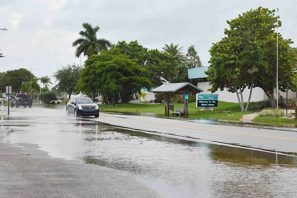
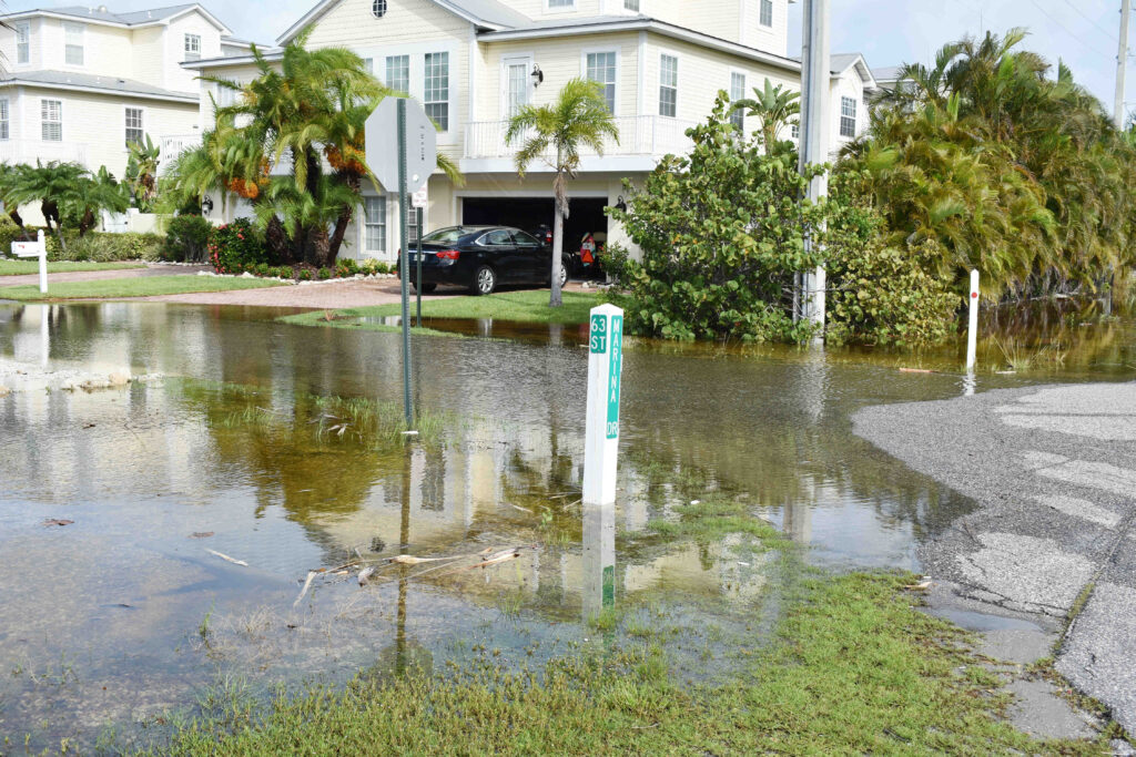
Holmes Beach
A pass through Holmes Beach at 7:30 Wednesday morning revealed standing water covering the edge of Marina Drive, near city hall and the Island Branch Library, but the travel lanes were not completely submerged. Standing water was also covering portions of some of the adjacent side streets.
The flooding along Marina Drive in Holmes Beach was limited to the edge of the road by the time the sun came up.
Photo: Joe Hendricks
When contacted later in the day, Holmes Beach Police Chief Bill Tokajer said that city fared well during the storm.
“I was out all day and night until 5:30 this morning. We had some flooding by city hall around 3 to 4 a.m. After the rain stopped, the water subsided pretty quickly. We had minor overnight flooding and one tree down in the parking lot of Martinique North. We dodged the bullet,” Tokajer said.
Standing water covered this portion of 63rd Street in Holmes Beach Wednesday morning.
Photo: Joe Hendricks
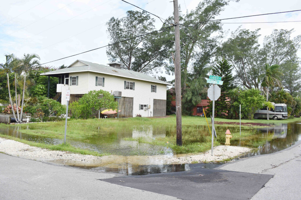
Anna Maria
At approximately 8 a.m., Anna Maria Mayor Dan Murphy and Public Works Manager Dean Jones were touring the city and accessing the storm damage.
“So far, we’re looking pretty good. We’ve got some local street flooding in the areas that would normally flood – and it’s not saltwater flooding, it’s rainwater flooding. There’s no trees down. All of our major roads are clear, but there’s some outlying areas and backstreets where we’ve got some issues with flooding. Some of that we’ll be able to pump out and some we won’t,” Murphy said.
This Anna Maria homeowner’s yard experienced Elsa-related flooding.
Photo: Joe Hendricks
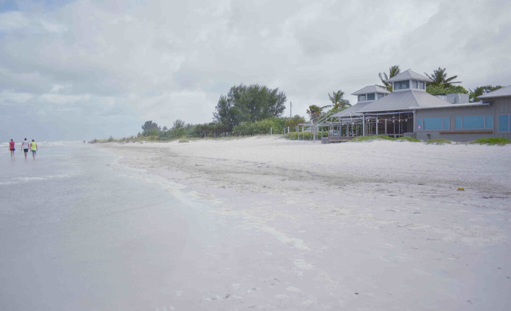
A tour around Anna Maria indicated North Bay Boulevard, near the Bean Point beach access, was among the most flooded areas.
The visit to the beach in front of the Sandbar restaurant revealed significant beach erosion may have occurred.
The beach in front of the Sandbar restaurant in Anna Maria appeared to have suffered beach erosion during the storm.
Photo: Joe Hendricks
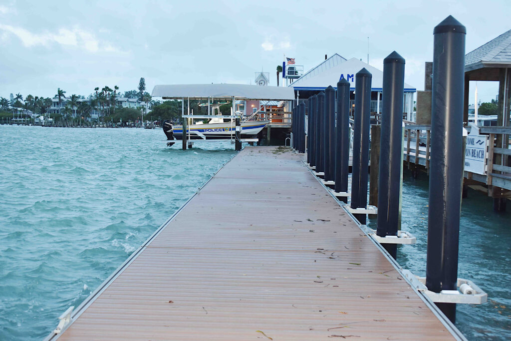
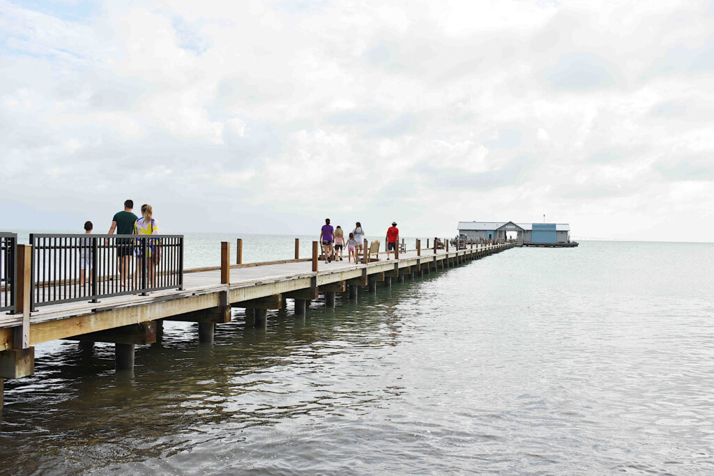
The new Anna Maria City Pier came through the storm unscathed and residents and visitors were going about their business as usual as the sun appeared and the new day got underway, with some intermittent sun showers throughout the day.
The new Anna Maria City Pier sustained no storm damage.
Photo: Joe Hendricks
The city’s “Reimagining Pine Avenue” public information meeting scheduled for 2 p.m. Wednesday afternoon was cancelled and rescheduled at 2 p.m. on Monday, July 12.
Cortez Beach
A mid-morning trip to Cortez Beach in Bradenton Beach revealed several people walking along the beach and few surfers in the water. Red flags were flying on the lifeguard tower and a member of the Manatee County Beach Patrol called a group of young men back to shore who had walked out to the end of one of the groins being battered by the high surf.
Due to high surf, these young men were asked to vacate a beach groin at Cortez Beach.
Photo: Joe Hendricks
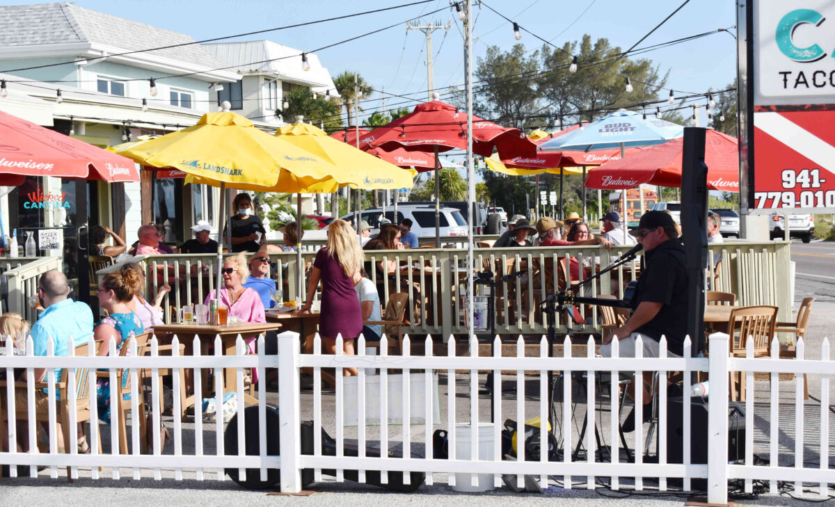
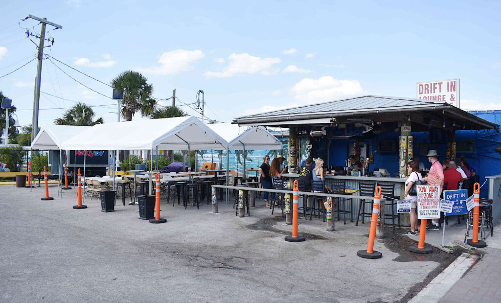
The current location of the Wicked Cantina’s live music is expected to be impacted by the city's new enforcement measures. Photo: Joe Hendricks
BRADENTON BEACH – Bradenton Beach establishments can continue using their temporarily expanded seating for outdoor seating, but an existing prohibition on live music in those areas will be enforced as of Friday, June 4.
On Thursday, June 3, the Bradenton Beach Commission is expected to adopt on final reading an ordinance that will allow the previously enacted expanded outdoor business operations to continue for an estimated two more months or so as businesses continue to recover from the losses suffered during the COVID-19 pandemic.
Thursday’s meeting will begin at 6 p.m. and public input will be allowed on this matter. The updated ordinance, 21-533, to be adopted Thursday is included in the meeting packet, beginning on page 91.
On Friday, May 28, Bradenton Beach Building Official Steve Gilbert and senior members of the Bradenton Beach Police Department crafted a written notice of prohibition and live entertainment update to be provided this week to impacted and potentially impacted establishments.
“Ordinance 20-516, adopted on May 21, 2020, provided for an expansion of outdoor dining due to the COVID-19 pandemic. The ordinance provided for a number of regulations pertaining to the expanded areas allowed. The ordinance also provided for several prohibitions. Section 5 expressly prohibits live entertainment and bands in the expanded outdoor dining areas,” the notice states.
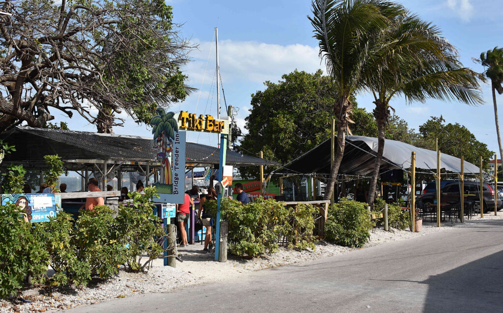
The Bridge Tender Inn’s temporarily expanded outdoor dining area currently includes a temporary outdoor stage toward the southern end of the property. Photo: Joe Hendricks
The temporary ordinance adopted in 2020 always prohibited live music in the expanded outdoor seating areas, but that prohibition was never enforced. As of last weekend, The Bridge Tender Inn and the Wicked Cantina still featured live music in their expanded outdoor dining areas; and The Drift In sometimes features live bands in its expanded outdoor seating area on weekend afternoons.
“The city has received complaints of live entertainment and bands in those expanded outdoor dining areas and is responding to these complaints. Be advised that effective June 4, city police and code enforcement officers will begin enforcement of this prohibition. Violations will result in the loss of any expanded outdoor dining areas,” the notice states.
The live music prohibition does not apply to live music areas used prior the temporary ordinance taking effect in 2020.
“This does not mean that those locations of live entertainment and bands in use prior to the effective date of Ordinance 20-516 are prohibited. However, in order to continue providing live entertainment and bands in those prior locations, a sketch of the previous location must be signed, dated, and submitted to the clerk’s office to be filed with the business tax receipt files,” the notice states.
The Drift In sometimes has outdoor bands on weekends. Photo: Joe Hendricks
The written update also includes an acknowledgement for the business owner or manager to sign.
“I hereby acknowledge that I have read this document and agree to cease live entertainment and bands in my expanded outdoor dining area. I also acknowledge that if this business previously provided live entertainment and bands, I will provide a sketch to indicate the location used prior to May 21, 2020 to the clerk’s office,” the acknowledgment states.
Recent city commission meetings have included informal discussion about possibly allowing the expanded outdoor dining areas to remain on a permanent basis, but no formal actions have been taken in that regard.
The 24th Street North street end is one of several areas being considered for future flood control improvements to be made using a state appropriation. Photo: Joe Hendricks
BRADENTON BEACH – The Bradenton Beach Commission is still contemplating which engineering firm or firms will be contracted or subcontracted to update the city’s master drainage study.
Last updated in 2006, the master drainage study update would provide an independent review of the successes and deficiencies of the existing drainage elements previously engineered by City Engineer Lynn Burnett and her LTA Engineers firm.
As a more pressing immediate need, the commission is also still contemplating which firm will be contracted to review and potentially reengineer the plans Burnett presented the commission in late April regarding a $2 million flood control project to be funded by a $2.69 million state appropriation.
The scope of outside engineering services sought in the RFP includes an update of the master drainage study, a review of Burnett’s plans for the state-funded flood control project, additional engineering recommendations regarding the failing brick paver crosswalks on Bridge Street and more.
The Land & Water Engineering Science proposal listed a total estimated price of $112,000. The UCOF proposal listed a total estimated price of $95,000 and UCOF would rely on Colliers Engineering to provide subcontracted stormwater engineering services. The Madrid/CPWG Engineering proposal listed a total estimated price of $50,000. Land & Water Engineering and Madrid/CPWG have their own in-house stormwater engineers on staff.
When making its May 11 selection, the commission directed City Attorney Ricinda Perry to attempt to negotiate a contract with Land & Water Engineering – with the understanding that the city, at that time, had no more than $60,000 to spend on stormwater and drainage related engineering services for the remainder of the fiscal year that ends Sept. 30.
City Attorney Ricinda Perry was authorized to negotiate with all three firms that responded to the city’s request for proposals. Photo: Joe Hendricks
According to the Consultant’s Competitive Negotiation Act, the city is to first attempt to negotiate a contract with the firm deemed most qualified by the commission – which is Land & Water Engineering. If the commission deems those initial negotiations unsuccessful, those negotiations would be terminated and Perry would be authorized to negotiate with the second ranked firm, and then the third ranked firm if need be. The commission can also discard all bids received.
During the commission’s May 20 meeting, Perry suggested an alternative selection and negotiation process. She told the commission she requested and received standard contracts from each of the three firms, and she recommended using any of those firms on a specific per-task basis.
Perry and the commission were surprised to learn from City Treasurer Shayne Thompson that the city actually had only $5,000 to $8,000 to spend on stormwater-related professional services for the remainder of the current fiscal year. Thompson said the rest of that $60,000 is already committed to the maintenance of existing stormwater systems.
Participating by phone, Commissioner Jake Spooner said he was “flabbergasted” to learn the city only has $5,000 to $8,000 to spend on additional stormwater engineering services.
Perry said Land & Water Engineering estimated $12,140 to simply review Burnett’s plans, without doing any additional reengineering, and UCOF estimated $8,000. Perry did not provide cost estimates from Madrid/CPWG.
Perry told the commission Land & Water Engineering could reengineer Burnett’s state appropriation plans for an estimated $42,120, and UCOF could provide those services for an estimated $36,000.
Spooner questioned the point of spending any of the remaining money on additional engineering reviews if the city has no money to act upon the engineering recommendations made. Despite the unresolved funding concerns, the commission authorized Perry to negotiate with all three firms.
The state appropriation places a cap on the percentage of the funds that can be used on engineering services. On more than one occasion, Spooner noted Burnett’s 90% completed plans have already cost the city approximately $168,000, which accounts for a significant portion of the total engineering and design costs allowed by the state.
The commission directed Perry to contact Florida Department of Environmental Protection Grant Manager Michael Scheinkman and seek the state agency’s permission to spend a greater percentage of the state funds on engineering services and slightly less on the actual construction costs. On Wednesday, May 26, Scheinkman informed Perry that some of the state funds can be used for additional engineering services.
A special city commission work meeting was scheduled for Friday morning, May 28, to allow for further discussion on the state-funded flood control project and any additional engineering that project may require. Photo: Joe Hendricks
At the request of Chappie, a commission work meeting was scheduled at 8:30 a.m. on Friday, May 28. The purpose of Friday’s meeting is to attempt to determine if another firm is going to be contracted to review Burnett’s plans for the state-funded project and provide additional options and cost estimates regarding other flood-prone areas that might be addressed instead or in addition to those included in Burnett’s plans.
State-funded project
Burnett presented her 90% completed flood control project plans to the commission on April 27. According to Perry, the fully completed engineering documents for the state-funded project must be submitted to the state by July 31. The project contractor must be selected by the end of October and the project must be completed by June 2023.
Burnett’s plans propose installing pervious pavers or pervious concrete, with underlying drainage components, at the unpaved street ends along the west side of Gulf Drive at 27th Street North, 26th Street North, 25th Street North, 24th Street North and the Third Street South street end. The commission has not yet determined whether the 23rd Street North street end should be included in those plans, because that area rarely floods.
Burnett said the proposed street end improvements would reduce flooding on Gulf Drive North, provide better ingress and egress for those properties and assist the city with its efforts to reclaim the city-owned rights of ways and parking areas at those street ends. She also noted the commission offered preliminary support for the proposed locations when discussed at the 60% design phase in October.
The map recently provided by Lynn Burnett highlights the proposed drainage improvements along Gulf Drive North and also along Avenue A. Photo: City of Bradenton Beach
The commission continues to question whether the proposed street end improvements are the best use of the state funds, and whether some of the state money might be better used on more flood-prone areas elsewhere in the city.
Burnett’s plans also propose making needed flood control improvements in the vicinity of the Avenue A and 20th Place North and 21st Place North; and possibly to the alley near Herb Dolan Park.
The commission considers Bay Drive South to be another flooding hotspot, but that area is not included in the current plans for the state-funded project. According to Chappie, city officials and city staff members are exploring other potential grants and funding sources that might cover the cost of that anticipated $500,000 project.
During the April meeting, Chappie expressed concerns about Burnett’s plans for the Avenue A drainage improvements including the installation of stone-covered infiltration trenches that have worked well in some areas, but proved problematic in other areas, including along Bridge Street. The stone-covered trenches require ongoing maintenance and those maintenance costs increase with each new infiltration trench installed according to Burnett’s engineering and design.
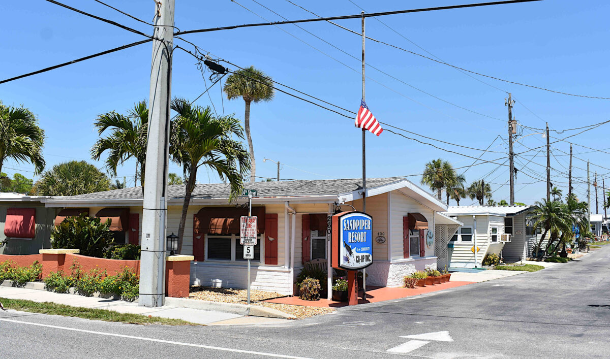
The map revisions could impact the Sandpiper Resort’s future land use and zoning designations. Photo: Joe Hendricks
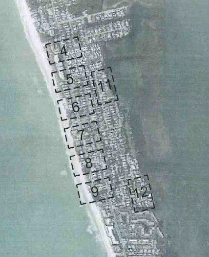
BRADENTON BEACH – The city of Bradenton Beach’s ongoing efforts to resolve inconsistencies that exist between the city’s future land use maps and zoning maps could potentially impact property values and the future use of many properties citywide.
The inconsistencies began when the city previously adopted a revised future land use map as part of its 2020 comprehensive plan. Building Official Steve Gilbert and City Planner Luis Serna are now guiding the planning and zoning board (P&Z) and the city commission through the early stages of the map revision process. The goal is to make the zoning and future land use maps consistent with each other.
The map revisions being considered are not intended to alter the current use of an impacted property. The map revisions would become more significant if the property is sold, if an existing structure or structures are demolished by a storm or some other disaster, or if a property owner wishes to redevelop their property in a manner that differs from its current use.
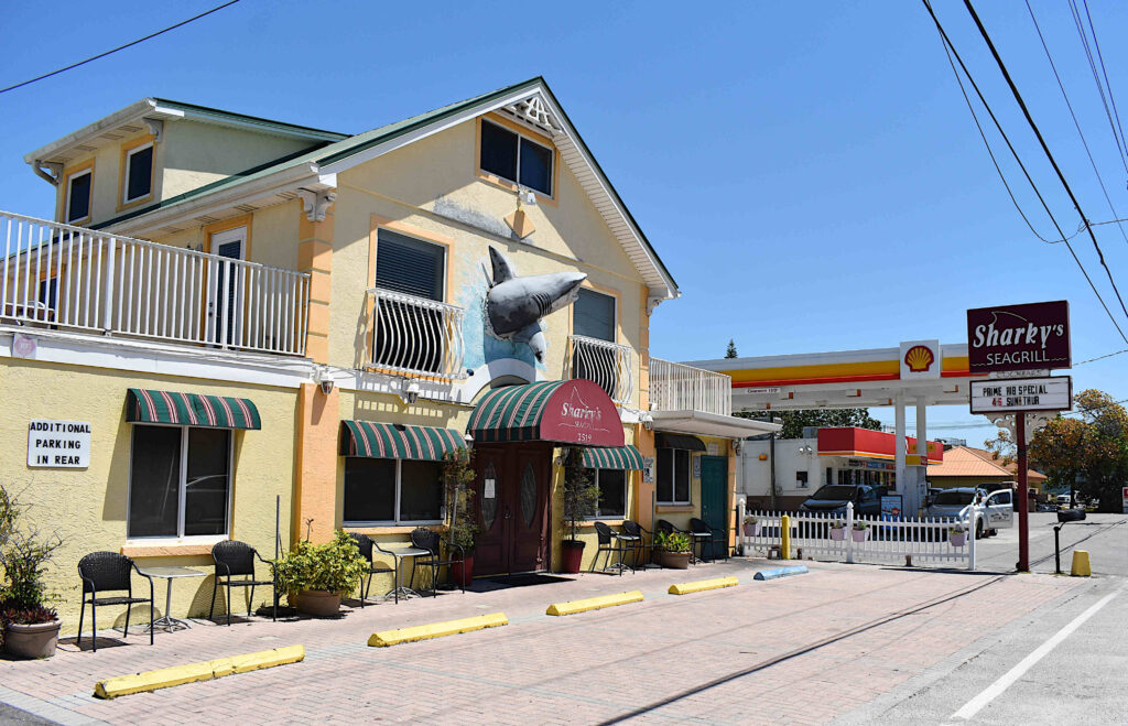
During the April 21 P&Z meeting, the future land use and zoning maps for the Sandpiper Resort Co-Op were discussed in-depth. The future land use and zoning map designations for several properties in the 2500 and 2300 blocks of Gulf Drive North were also discussed in-depth.
The potentially impacted properties in the 2500 block of Gulf Drive North include Sharky’s Seagrill, the Shell gas pumps and Circle K convenience store, a vacant lot, Club Bamboo and the two-story structure occupied on the ground level by the Studio 104 salon, the KW on the Water real estate office and the Blooms by the Beach florist shop, with residential units located above.
Similar map inconsistencies exist in the 2300 block of Gulf Drive and could potentially impact the Aluna Wellness Center & Spa and Wagner Real Estate properties.
Sharky’s Seagrill, the Shell gas pumps and the Circle K convenience store properties are among those that could be impacted by the proposed map revisions. Photo: Joe Hendricks
Several other potentially impacted properties throughout the city that have not yet been discussed by the P&Z board. The maps for the properties citywide that may be impacted by the map revisions can be viewed here.
The board’s map revision discussions will continue at 11 a.m. on Wednesday, May 5, and are also expected to be discussed at the Wednesday, May 19, P&Z meeting.
During the April 21 meeting, Gilbert said the purpose of that day’s meeting was for the P&Z members to review the proposed map revisions and make their recommendations to the city commission. The city commission has the sole authority to make any final decisions regarding map revisions.
“This is not a public hearing to formally adopt these maps,” Gilbert noted.
Sandpiper Resort
In 2008, the city commission amended the future land use map in a manner that decreased the maximum units allowed on the majority of the Sandpiper property from 18 units per acre to nine. But the coinciding zoning map that establishes the M-1 (mobile home park) zoning district was not revised in 2008 and has not been revised since then.
The land development code allows a specific number of lots on the Sandpiper property, and the number of lots allowed exceeds the density established by the current future land use map.
According to the existing future land use map, the majority of the Sandpiper property carries a medium density residential land use designation. The portion of the property closest to the Anna Maria Sound shoreline carries a low density residential land use designation.
The zoning and future land use designations for Sandpiper Resort property (at the top of this map) and the properties located in areas marked as #4 were discussed at the April 21 meeting. Photo: Joe Hendricks
Gilbert and Serna recommend amending the future land use map designation to high density residential, which would return the Sandpiper’s future land use designation to its pre-2008 status.
P&Z member John Burns opposed that action and instead proposed revising the zoning map to match the nine units per acre currently allowed by the future land use map.
The board members expressed concerns that revising the zoning map to allow 18 units per acre could result in a more intense future use of the Sandpiper Resort property should it ever be redeveloped as something other than a mobile home park. Burns said reversing the 2008 future land map use amendment would double the allowed density.
City Planner Luis Serna advised against making map revisions that could devalue properties and property rights. Photo: Joe Hendricks
In response, Serna said, “The intent is to reflect what’s on the ground there currently. This was a change that occurred in 2008 which is basically making those properties non-conforming. They confirm to the zoning, but the zoning does not conform to the future land use. We’re really just trying to give them back what they had prior to 2008.”
Burns said he was not aware of any Sandpiper Resort property owners who objected to the 2008 future land use map revision.
“I’m not sure what the public response was back then, but it is definitely something where the city is out of compliance with its own plan. That’s a concern,” Serna said.
Gilbert said the Sandpiper property has historically been zoned M-1, under the high density residential criteria and changing that zoning would have consequences.
“We would be taking away dwelling unit density from them. Which is why we’re recommending to make this (the future land use map) consistent with the historic use and the current use rather than rezoning it and potentially causing damage to their property value by changing future land use back to what it was before this map was done,” Gilbert said.
Building Official Steve Gilbert explained the map revision options and potential consequences. Photo: Joe Hendricks
Board member Bill Morrow asked if the Sandpiper Resort community is currently configured to nine units per acre. Gilbert said the current density is much higher than that.
“There are two choices to be made here: one is to revert back to high density for that entire parcel and a future developer could fit quite a few units in there. If you keep it the way it is, future developers are not going to be able to pack as many buildings or dwelling units in there. The second option is to change it (the future land use designation) back so that the mobile home park remains conforming to current zoning, but that also gives them the ability, if they choose sell the property, to develop the property at 18 units per acre,” Gilbert said.
“I see no benefit to the city nor to adjacent properties in changing it back to the way it was,” Burns said.
The board voted 5-0 in support of Burns’ motion to recommend the city commission amend the zoning map to match the nine units per acre currently allowed by the future land use map. The P&Z recommendation is not what Gilbert and Serna recommend.
Gulf Drive North
The board also the map inconsistencies that exist in the 2500 and 2300 blocks of Gulf Drive North.
The future land use map currently designates those areas as R-2 medium density residential with a C-2 general commercial zoning designation.
“All the uses on the property are commercial,” Serna said of the existing property uses.
Serna and Gilbert recommend amending those future land use map designations to Retail/Office/Residential (ROR) in order to be consistent with the existing zoning and current uses of those properties.
Burns expressed concerns that commercially zoned property with an ROR future land use designation would allow new structures to be built with 90% lot coverage.
“You might have 90% lot coverage when you get done with the parking lot, but building coverage, no,” Gilbert responded.
Board member Fred Bartizal said he likes the existing zoning the way it is.
“Why change it?” Burns asked.
“Because the uses of the property are not residential,” Serna replied.
Serna said the Circle K property is zoned C-2 but the future land use designation is medium density residential. “That’s where the inconsistency is,” he noted.
Burns asked if a new Circle K building could be built on that property if a storm or some other disaster destroyed the existing structure.
In response, Gilbert said, “Not really, because C-2 zoning is not consistent with the medium density dwelling as established by the future land use map. The future land use map says zero to nine dwelling units per acre and no commercial development is to occur there. It’s a residential land use. Your commercial zoning is not consistent with your comprehensive plan and the existing uses there would become non-conforming uses. In order to make them conforming, you either change the future land use map or you change the zoning. To preserve the character of what’s up there now, the future land use map goes to ROR and the zoning goes to mixed-use, rather than commercial.”
P&Z board member John Burns does not support increasing density allowances to correct existing map inconsistencies. Photo: Joe Hendricks
“The comp plan is saying that should be residential and what’s on the ground isn’t residential. That’s all we’re trying to fix,” Serna said.
“You’re opening a can of worms to fix it,” Burns replied.
Serna said not allowing commercial structures in those areas could subject the city to legal challenges.
“They could sue the city and that’s the concern we’re trying to address. We don’t want to take away anyone’s rights through down-zoning,” Serna said.
Regarding properties made non-conforming with city code due to past or future commission actions, Serna said, “They can exist as long as they’re not destroyed, but the owners of those properties could rightly come and say we’ve had a development right under zoning and now it’s being taken away.”
Board member Fred Bartizal expressed concerns about making zoning revisions that could potentially allow for more intense development.
“What worries me is there’s some pretty smart developers out there right now with some real smart lawyers. If we change any of them, will it make it easier for them?” he said.
Board chair Ken McDonough noted the current challenge for the city is what happens if a property owner wants to develop a property where there are existing inconsistences between the zoning and future land use maps.
“What do you do? Do you go by the zone map? Do you go by the future land use map?” he asked.
“That’s why we’re having this discussion,” Gilbert said. “There’s a vacant lot next to the Circle K. It’s zoned C-2. The land use is duplex and they want to put in shopping. If we follow the zoning it will become a duplex.”
The board unanimously supported Burns’ motion to recommend the city commission change the zoning map to match the current future land use map, which is medium density residential, R-2 – which allows single-family residences or multi-family duplexes and apartments. The board recommendation not what Gilbert and Serna recommend.
Gilbert noted that before any final map revision decisions are made by the city commission, all potentially impacted property owners will be notified and will have the opportunity to address the P&Z board and the city commission when future public hearings are held.
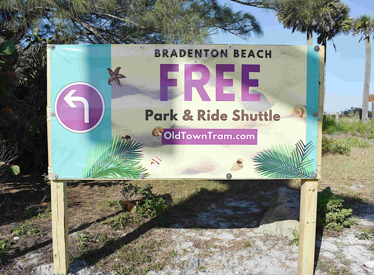
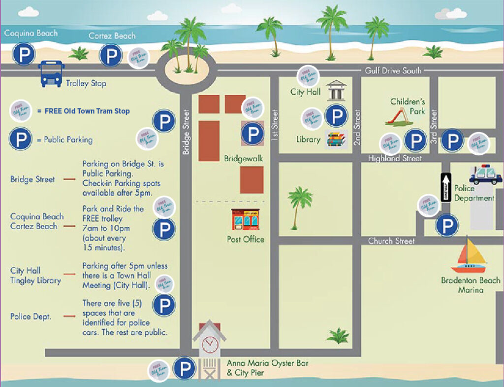
This new tram banner is located at the Gulf Drive/Cortez Road intersection at the west end of the Cortez Bridge. Photo: Joe Hendricks
BRADENTON BEACH – Banners are now in place as part of the Bradenton Beach Community Redevelopment Agency’s (CRA) ongoing efforts to make more people aware of the free Old Town Tram parking tram service.
The free park and ride shuttle service is provided within the CRA district boundaries that extend from the Cortez Bridge to Fifth Street South and include the Bridge Street business district.
One banner is placed at the entrance to the city at the west end of the Cortez Bridge.
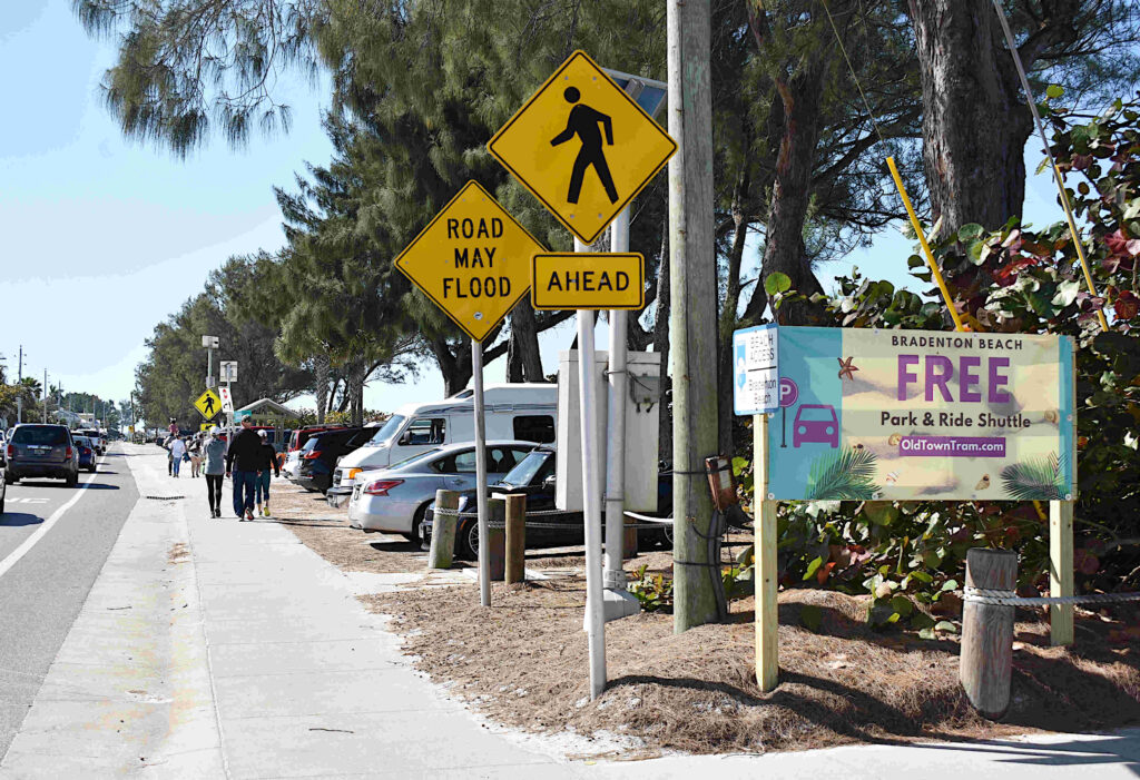
Another banner is placed south of the Gulf Drive/Bridge Street roundabout, at the 4th Street South intersection that marks the north end of the Cortez Beach parking lot, where drivers are encouraged to park and catch a free tram to their desired destination.
This Old Town Tram banner is located just north of the Cortez Beach parking lot, which is among the locations serviced by the free trams. Photo: Joe Hendricks
A third banner is located near the east end of the Cortez Bridge in hopes of catching the eyes of folks headed over the bridge and into Bradenton Beach.
The free electric trams also service the parking areas near the Bradenton Beach Police Station and the Bradenton Beach Marina, the city hall parking lot after normal business hours, along Bridge Street, near the Bridge Street Pier and elsewhere throughout the CRA district.
The Old Town Trams make frequent passes by the Cortez Beach parking lot south of the Bridge Street/Gulf Drive intersection. Photo: Joe Hendricks
Traveling a designated route, a tram is expected to pass by any given point along the route every 10 minutes or so – and the ringing of a ship’s bell signals a tram’s approach.
Upon parking, pickup can also be arranged by calling 941-404-6240. More information, including a tram route map, is available online at www.oldtowntram.com.
This map illustrates the Old Town Tram route. Photo: www.oldtowntram.com
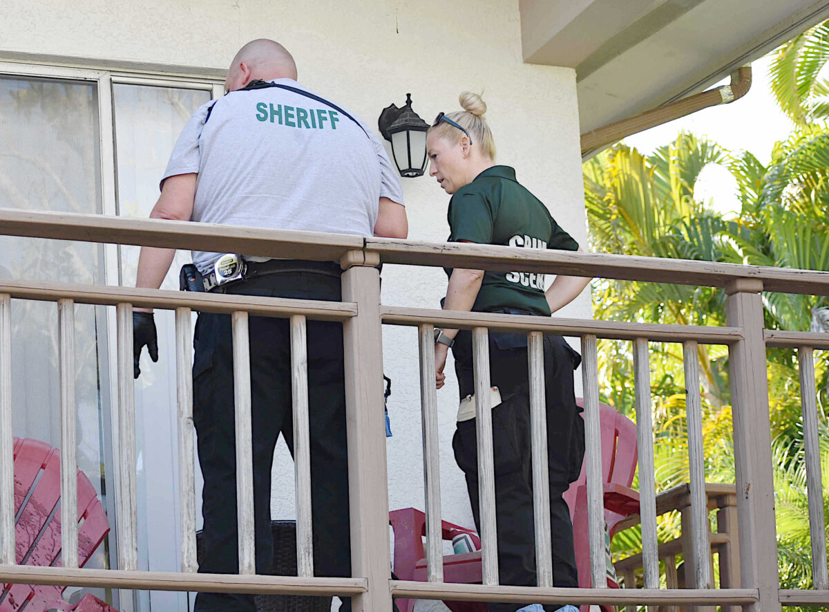
Members of the Manatee County Sheriff's Office Crime Scene Unit assisted with the investigation. Photo: Joe Hendricks
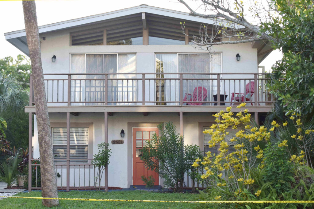
BRADENTON BEACH – The Bradenton Beach Police Department has released the final findings on the murder-suicide that occurred in the upper level of a triplex at 2514 Ave. C in October.
Det. Sgt. Lenard Diaz released those final findings on Friday afternoon. According to the 17-page report, the medical examiner’s autopsy determined 37-year-old Sabrina Dumdei’s cause of death was “incised wounds of the neck” and her manner of death was “Homicide – Cut by other person with box cutter.”
The medical examiner’s findings note Dumdei’s fatal injuries included stab wounds and incised wounds to the head, neck, throat, torso, cervical vertebrae, extremities and muscles, and abrasions and contusions of the skin.
“The toxicology reports stated that Dumdei was positive for Ethanol in blood 0.32 G/DL (blood alcohol concentration) and urine 0.37 G/DL,” according to Diaz’s summary report of the medical examiner’s findings.
According to the report, the cause of death for Zachary Winton, 34, was “incised wounds of the neck and upper extremity” and the manner of death was “Suicide – Cut self with box cutter.”
The medical examiner determined Winton had incised wounds of the neck and upper extremity, superficial incised wounds of the torso, blunt impact injuries that included subgaleal hemorrhage and also abrasions and lacerations of the skin.
“The toxicology report stated that Winton was positive for Ethanol in blood 0.24 G/DL (blood alcohol concentration) and urine 0.31 G/DL,” according to Diaz’s report.
The summary of the medical examiner’s findings states the Bradenton Beach Police Department had previously responded to domestic incidents involving Dumdei and Winton at that address.
“It was a known fact that Dumdei and Winton had been arguing with each other the whole week leading up to their deaths,” Diaz stated in his final report.
“During this investigation, several interviews were conducted, evidence was collected, crime scene techs responded and processed the scene along with medical examiner investigators and the medical examiner herself. I also invited the Manatee County Sheriff’s Office Homicide Task Force, which I am a part of, to come to the scene for an extra set of eyes a few days after,” Diaz stated in his report.
“At this time, this case is closed as a murder/suicide. If any further information arises, a supplement will be done to this case,” Diaz’s report says in closing.
Incident narrative
The final report Diaz released Friday includes the incident narrative he included in his original offense report dated Oct. 17.
According to that narrative, Diaz and Lt. John Cosby were dispatched to 2514 Ave. C on Saturday, Oct. 17, and advised that two dead people had been discovered by the victim’s father, Keith Dumdei.
“The father stated that he observed his daughter through the glass windows on the door, laying on the living room floor in a pool of blood. Keith advised that he had made entry by punching one of the small glass windows on the door,” the report states, noting the door was locked at the time.
According to the report narrative, Diaz and Cosby then entered the home and observed a female lying on the floor, covered with blood and laying in a pool of blood.
“We also noticed blood everywhere,” Diaz stated in his report, noting that Cosby then walked further into the house and discovered Winton’s body in the bedroom, on the bed.
Sabrina Dumdei and Zachary Winton were found dead inside this Bradenton Beach triplex in October. Photo: Joe Hendricks
The narrative states, “The Dumdei family advised that they had received information from Winton’s sister, Wendy, through Facebook Messenger that Wendy had not been able to reach her brother or Sabrina all day. One of the Dumdei sisters called their dad, Keith. Keith stated that he was already heading toward the beach, so he could go to the house and check on them. Upon pulling into the driveway, they found Sabrina’s little dog outside. They knew something was wrong. The family stated the dog never left Sabrina’s side. That was when Keith went upstairs,” Diaz stated in his narrative.
“We were able to identify both suspects due to being at the residence in the past for a disturbance and prior domestic violence arrest, and by the family identification,” the narrative notes.
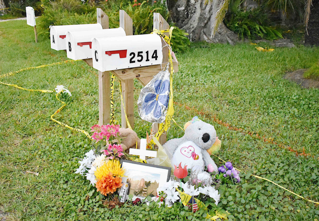
In the days that followed, these items placed outside the triplex served as a memorial for Sabrina Dumdei. Photo: Joe Hendricks
Diaz’s narrative states he spoke with a man who had been vacationing with his family in a rented home at 2517 Ave. C since Sunday, Oct. 11. The man told Diaz the couple at 2514 Ave. C argued numerous times that week, including while walking down the road. The man told Diaz at one point he heard the couple arguing while walking and “The male yelled that he was going to kill her.”
Diaz spoke with another female who was living nearby and saw the couple walking and arguing during the middle of that week. Diaz also spoke with neighbors and visitors who heard no disturbances.
According to Diaz’s narrative. Winton’s sister, Wendy, woke up that Saturday morning and noticed she had missed three calls from her brother, Zachary. Those missed calls were made at approximately 7, 8 and 9 p.m. Friday evening.
“According to Wendy, the last call to her from Zachary’s phone was a message. The message was a voice message of Sabrina yelling at Zachary that he was the one that was going to have to leave. Wendy advised that after hearing that last missed call, she tried contacting Zachary and Sabrina but could not reach either of them. Wendy stated that she then messengered Sabrina’s sisters on Facebook and asked if they could go by and check on Sabrina and Zachary,” Diaz stated in his narrative.
Previous death threat
According to court records, Winton was arrested by the Bradenton Beach Police Department on Aug. 31 on alleged charges of aggravated assault with a deadly weapon, tampering with a witness, false imprisonment and domestic battery.
The victim’s name and the address were redacted in the probable cause affidavit prepared then by officer Steve Masi, but after the suspected murder-suicide occurred Diaz confirmed Dumdei was the victim in the August incident that occurred at the same Avenue C address.
According to the probable cause affidavit Masi filed, “Defendant and victim had been arguing for the last two days. Victim stated Winston refused to let her leave the house, or his sight, by threats of violence. Defendant then grabbed her by the face and held a razor knife to her neck and said, ‘Leave and see what happens.’ Victim had a well-founded fear that Winton had the ability to carry out such a threat and that it would take place. Victim finally got away and made the call to 911 dispatch but had to hang up in the middle of the call, as defendant had found her and once again put her in fear of violence.”
“Upon my arrival, defendant was yelling and walking at victim with a large kitchen knife I observed in his right back pocket. Defendant was issued verbal commands at taser point to back away from the victim. He then complied and was detained. While detained in the police department, Winton made numerous threatening remarks about what he was going to do to victim when he gets out, such as ‘If I get charged with felonies, I’ll kill her then myself. I will cut her throat,’” according to the probable cause affidavit.
According to court records, Winton’s attorney, Jacob Grollman, filed a motion on Sept. 9 seeking to allow Winton consensual contact with Dumdei. On Sept. 15, the no contact order was lifted and the status of Winton’s criminal case was still pending at the time of their deaths.
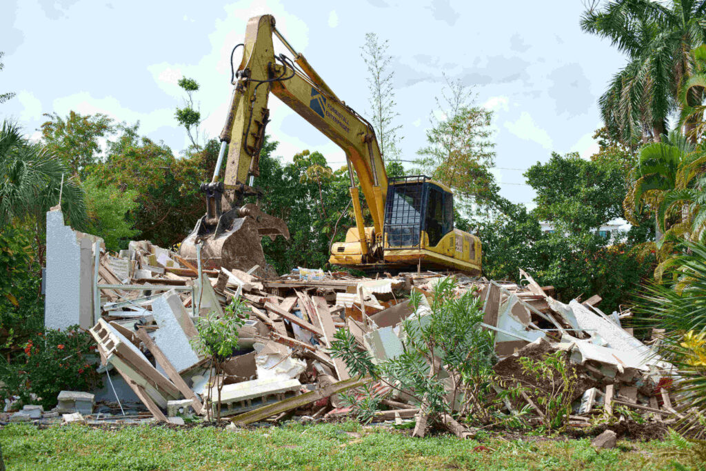
In November, the triplex was demolished by the new owners who purchased the property shortly before the fatal incident occurred.
The Avenue C triplex was demolished in November. Photo: Joe Hendricks